 usdata
An EF4 tornado struck Osage County, Oklahoma on the evening of 6 May 2024. This study pins two inputs: every NWS watch, warning, and advisory issued for the county that evening, and the 2024 Storm Events archive, which holds the report of the tornado. Setting each warning's issuance beside the report's start time gives a lead time, and shows what a county-level record can and cannot say about it.
It needs usdata[pandas] and matplotlib. The first run downloads about
13 MB, almost all of it the year's Storm Events archive, and takes a few
seconds.
Show code
from datetime import UTC, datetime
from pathlib import Path

import matplotlib.dates as mdates
import matplotlib.pyplot as plt
import pandas as pd
from matplotlib.patches import Patch

import usdata
from usdata import cite_lockfile, pull, verify

# One figure style for every usdata notebook, so previews look alike.
plt.rcParams.update(
    {
        "figure.figsize": (8, 4.5),
        "figure.dpi": 120,
        "axes.spines.top": False,
        "axes.spines.right": False,
        "axes.grid": True,
        "grid.alpha": 0.3,
        "font.size": 10,
    }
)
manifest = Path("dataset.yaml")
print("Executed (UTC):", datetime.now(UTC).isoformat(timespec="seconds"))
print(f"usdata {usdata.__version__}; pandas {pd.__version__}")
Executed (UTC): 2026-09-24T06:06:29+00:00
usdata 0.26.0; pandas 3.0.6
Data
- NWS watches, warnings, and advisories,
named
warnings: one row per VTEC event, from the Iowa Environmental Mesonet's archive of the NWS product stream. The source is selected by an exact county:Osage County, OKbecomes the NWS codeOKC113, the state's postal code,C, and the county FIPS code. A bounding box could not do that, and is refused. - Storm Events, named
reports: NCEI's archive of reported storms, for the tornado's start and end times. It is published as one file per year, so the one-day window selects the whole 2024 file.
The warnings window selects events by when they were issued, not by when they were in effect. To ask what was in effect at some moment, the window has to reach back far enough to catch everything still running, as this one does from 18:00 UTC.
Show code
print(manifest.read_text())name: osage-tornado-warning-lead-time
sources:
- name: warnings
dataset: noaa:nws-vtec-events
location: Osage County, OK
start: 2024-05-06T18:00Z
end: 2024-05-07T12:00Z
- name: reports
dataset: noaa:storm-events
start: 2024-05-06
end: 2024-05-06
Show code
result = pull(manifest)
for item in result.fetched:
    print(item.asset.dataset_id)
    print(f"File: {item.path.name}")
    print(f"Bytes: {item.provenance.size}; cache hit: {item.from_cache}")
    print("Source:", item.provenance.source_url)
    print("Retrieved (UTC):", item.provenance.retrieved_at.isoformat(timespec="seconds"))
    print("Checksum:", item.provenance.checksum)
    print()
noaa:nws-vtec-events
File: vtec_OKC113_20240506_20240507_9048c17737f26bcb97ac.csv
Bytes: 3571; cache hit: False
Source: https://mesonet.agron.iastate.edu/json/vtec_events_byugc.py?ugc=OKC113&sts=2024-05-06T18%3A00%3A00Z&ets=2024-05-07T12%3A00%3A01Z&fmt=csv
Retrieved (UTC): 2026-09-24T06:06:29+00:00
Checksum: sha256:1afb1397a85ffb0b5b0234c29d0a55176ee1b5ac24de1690c8832e5c3a0691a5
noaa:storm-events
File: StormEvents_details-ftp_v1.0_d2024_c20260728.csv.gz
Bytes: 12693243; cache hit: False
Source: https://www.ncei.noaa.gov/pub/data/swdi/stormevents/csvfiles/StormEvents_details-ftp_v1.0_d2024_c20260728.csv.gz
Retrieved (UTC): 2026-09-24T06:06:41+00:00
Checksum: sha256:2070b83eccab041b36360ab73645b9a249c3eefc5b92b5b3fc0cbba4d9fcc09c
The tornado
Storm Events gives each report's start and end in the county's local standard
time; the reader adds BEGIN_UTC and END_UTC. Event 1184254 is the EF4's
Osage County segment.
Show code
warnings = result.one("warnings").open_csv(parse_dates=["iso_issued", "iso_expired"])
reports = result.one("reports").open()
print(f"Storm Events rows for 2024: {len(reports):,}")
tornado = reports[reports["EVENT_ID"] == "1184254"].iloc[0]
start, end = tornado["BEGIN_UTC"], tornado["END_UTC"]
columns = ["EVENT_ID", "EVENT_TYPE", "TOR_F_SCALE", "CZ_NAME", "BEGIN_DATE_TIME"]
columns += ["CZ_TIMEZONE", "BEGIN_UTC", "END_UTC", "TOR_LENGTH", "TOR_OTHER_CZ_NAME"]
tornado[columns].to_frame("value")
Storm Events rows for 2024: 69,801
| value | |
|---|---|
| EVENT_ID | 1184254 |
| EVENT_TYPE | Tornado |
| TOR_F_SCALE | EF4 |
| CZ_NAME | OSAGE |
| BEGIN_DATE_TIME | 06-MAY-24 20:12:00 |
| CZ_TIMEZONE | CST-6 |
| BEGIN_UTC | 2024-05-07 02:12:00+00:00 |
| END_UTC | 2024-05-07 02:57:00+00:00 |
| TOR_LENGTH | 32.4 |
| TOR_OTHER_CZ_NAME | WASHINGTON |
The report starts the tornado at 20:12 CST on 6 May, which is 02:12 UTC on 7 May, and ends it at 02:57 UTC, 4 miles east-northeast of Osage to 7 miles east of Okesa. It continued into Washington County as a second segment.
The county's evening
Every event issued for the county between 18:00 UTC on 6 May and 12:00 UTC on 7 May, by type and office.
Show code
print(f"{len(warnings)} events, from office(s): {sorted(warnings['wfo'].unique())}")
warnings.groupby(["ph_name", "sig_name"]).size().rename("events").to_frame()
14 events, from office(s): ['TSA']
| events | ||
|---|---|---|
| ph_name | sig_name | |
| Flash Flood | Warning | 1 |
| Flood | Advisory | 1 |
| Severe Thunderstorm | Warning | 7 |
| Tornado | Warning | 4 |
| Watch | 1 |
Which warning was in effect
Set each Tornado Warning's issuance and expiry beside the report's start.
iso_issued and iso_expired are the timezone-aware pair; issued and
expired hold the same instants in a second format.
Show code
tornado_warnings = warnings[
    (warnings["phenomena"] == "TO") & (warnings["significance"] == "W")
].sort_values("iso_issued")
minutes = pd.Timedelta(minutes=1)
table = pd.DataFrame(
    {
        "warning": tornado_warnings["eventid"],
        "issued (UTC)": tornado_warnings["iso_issued"].dt.strftime("%H:%M"),
        "expired (UTC)": tornado_warnings["iso_expired"].dt.strftime("%H:%M"),
        "issued, min before start": (start - tornado_warnings["iso_issued"]) // minutes,
        "expired, min after start": (tornado_warnings["iso_expired"] - start) // minutes,
        "in effect at start": (tornado_warnings["iso_issued"] <= start)
        & (tornado_warnings["iso_expired"] > start),
    }
).set_index("warning")
table| issued (UTC) | expired (UTC) | issued, min before start | expired, min after start | in effect at start | |
|---|---|---|---|---|---|
| warning | |||||
| 44 | 01:34 | 02:00 | 38 | -12 | False |
| 45 | 01:56 | 02:45 | 16 | 33 | True |
| 46 | 02:14 | 02:45 | -2 | 33 | False |
| 47 | 02:35 | 03:15 | -23 | 63 | False |
Show code
in_effect = tornado_warnings[
    (tornado_warnings["iso_issued"] <= start) & (tornado_warnings["iso_expired"] > start)
]
lead = start - in_effect["iso_issued"].min()

# Walk back from the start through overlapping tornado warnings to find how long
# some tornado warning naming the county had been continuously in effect.
covered_since = in_effect["iso_issued"].min()
for issued, expired in zip(
    tornado_warnings["iso_issued"][::-1], tornado_warnings["iso_expired"][::-1], strict=True
):
    if issued < covered_since <= expired:
        covered_since = issued
watch = warnings[(warnings["phenomena"] == "TO") & (warnings["significance"] == "A")].iloc[0]

print(f"The EF4 began at {start:%H:%M} UTC on {start:%d %B %Y}.")
print(
    f"Tornado Warning {in_effect['eventid'].iloc[0]} was in effect, "
    f"issued {lead // minutes} minutes earlier."
)
print(
    f"A tornado warning naming the county had been in effect continuously since "
    f"{covered_since:%H:%M} UTC, {(start - covered_since) // minutes} minutes before."
)
print(
    f"The Tornado Watch was issued at {watch['iso_issued']:%H:%M} UTC, "
    f"{(start - watch['iso_issued']) / pd.Timedelta(hours=1):.1f} hours before."
)
The EF4 began at 02:12 UTC on 07 May 2024.
Tornado Warning 45 was in effect, issued 16 minutes earlier.
A tornado warning naming the county had been in effect continuously since 01:34 UTC, 38 minutes before.
The Tornado Watch was issued at 19:05 UTC, 7.1 hours before.
Every Osage County alert running between 01:00 and 04:00 UTC on 7 May, with the tornado's time on the ground shaded.
Show code
window_start = pd.Timestamp("2024-05-07T01:00Z")
window_end = pd.Timestamp("2024-05-07T04:00Z")
shown = warnings[
    (warnings["iso_expired"] > window_start) & (warnings["iso_issued"] < window_end)
].sort_values("iso_issued", ascending=False)
colors = {("TO", "W"): "#b42318", ("SV", "W"): "#d99a1e", ("TO", "A"): "#e8b4ae"}

fig, ax = plt.subplots(layout="constrained")
ax.axvspan(mdates.date2num(start), mdates.date2num(end), color="#444444", alpha=0.12)
ax.axvline(mdates.date2num(start), color="#444444", linewidth=0.9)
for row, event in enumerate(shown.itertuples()):
    left = mdates.date2num(max(event.iso_issued, window_start))
    right = mdates.date2num(min(event.iso_expired, window_end))
    color = colors.get((event.phenomena, event.significance), "#9aa0a6")
    ax.barh(row, right - left, left=left, height=0.6, color=color)
ax.set_yticks(range(len(shown)))
ax.set_yticklabels(f"{e.ph_name} {e.sig_name} {e.eventid}" for e in shown.itertuples())
ax.set_xlim(mdates.date2num(window_start), mdates.date2num(window_end))
ax.xaxis.set_major_locator(mdates.MinuteLocator(byminute=[0, 30], tz=UTC))
ax.xaxis.set_major_formatter(mdates.DateFormatter("%H:%M", tz=UTC))
ax.set_xlabel("7 May 2024 (UTC)")
ax.grid(axis="y", visible=False)
ax.set_title("Osage County, OK: NWS alerts around the 6 May 2024 EF4")
fig.legend(
    handles=[
        Patch(color=colors[("TO", "W")], label="Tornado Warning"),
        Patch(color=colors[("SV", "W")], label="Severe Thunderstorm Warning"),
        Patch(color=colors[("TO", "A")], label="Tornado Watch"),
        Patch(color="#444444", alpha=0.12, label="EF4 on the ground (Storm Events)"),
    ],
    loc="outside lower center",
    ncols=4,
    frameon=False,
    fontsize=8,
)
plt.show()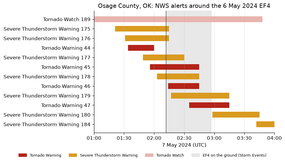
What a county record can and cannot say
Which of those numbers is "the lead time" depends on something these rows
cannot say. A warning is a polygon, and a county is listed on it when the
polygon touches the county. Osage is the largest county in Oklahoma, so
warning 44 may have been for a different part of it, or a different storm,
than the one that produced this tornado. The 16 minutes is safe to state as
"a tornado warning naming this county was in effect, issued 16 minutes
earlier". It is not a verification statistic, which needs the polygons;
noaa:nws-warnings is the
planned source for those. Query details are in the
warnings guide.
Pin and cite
verify checks the cached bytes against the lockfile. IEM processes the live
NWS product stream and states no schedule for revising its archive; the same
request returned identical bytes when repeated. NCEI republishes the Storm
Events file under a new name when it revises a year. If a later pull reports
drift, usdata pull dataset.yaml --update <dataset> accepts the revised
bytes. Keep the manifest, lockfile, and cached bytes together; the citations
below are what a methods section needs, and usdata cite dataset.yaml prints
the same.
Show code
assert verify(manifest) == []
for citation in cite_lockfile(manifest):
    print(citation.as_text())
noaa:nws-vtec-events
National Weather Service watch, warning, and advisory products, as archived and served by the Iowa Environmental Mesonet of Iowa State University, accessed via usdata
homepage: https://mesonet.agron.iastate.edu/info/datasets/vtec.html
license: Public domain (NWS products; IEM materials are public domain, attribution appreciated)
terms: https://mesonet.agron.iastate.edu/disclaimer.php
retrieved: 2026-09-24; 1 checksummed asset (3,571 bytes) pinned by usdata 0.26.0
sources: warnings
noaa:storm-events
NOAA National Centers for Environmental Information, Storm Events Database, accessed via usdata
homepage: https://www.ncei.noaa.gov/access/storm-events-database/
license: US Government Work (public domain)
terms: https://www.ncei.noaa.gov/metadata/geoportal/rest/metadata/item/gov.noaa.ncdc:C00510/html
retrieved: 2026-09-24; 1 checksummed asset (12,693,243 bytes) pinned by usdata 0.26.0
sources: reports
What was awkward
- The obvious question, "what was in effect at 02:12?", is not one the service can be asked. A window from 02:00 to 02:30 returns three events issued inside it, the 02:14 Tornado Warning among them, and misses warning 45, the one that was actually in effect, because it was issued at 01:56. The window has to reach back far enough to catch everything still running, and how far is a judgment: these warnings ran 26 to 49 minutes, and the watch nearly nine hours.
- The service's date-only parameters return nothing for spans that hold
thirteen events, with no error. The adapter never sends them, but a first
probe with
curland plain dates reads like an empty archive. - Two timestamps that look interchangeable are not.
issuedandexpiredare the same instants asiso_issuedandiso_expiredin a second format, and only the ISO pair parses with a timezone. - One tornado report costs the whole year's Storm Events file, about 13 MB compressed and some 70,000 rows; the manifest's one-day window does not filter rows.
- Storm Events splits a tornado that crosses a county line into segments. This EF4 continued into Washington County as a second row, so a question about the whole track has to find and join the segments.