 usdata
On the evening of 6 May 2024 tornadoes touched down across northern and central Oklahoma. This study pins two inputs: FEMA's major disaster declarations in force in Oklahoma that day, one row per designated county, and the 2024 Storm Events archive, which holds that evening's tornado reports. Joining them by county answers the question, and shows why this source is selected by a named place rather than by a rectangle.
The answer is about designation, not damage. It needs usdata[pandas] and
matplotlib. The first run downloads about 13 MB, almost all of it the year's
Storm Events archive, and takes a few seconds.
Show code
from datetime import UTC, datetime
from pathlib import Path

import matplotlib.pyplot as plt
import pandas as pd
from matplotlib.patches import Patch
from matplotlib.ticker import MaxNLocator

import usdata
from usdata import cite_lockfile, pull, verify

# One figure style for every usdata notebook, so previews look alike.
plt.rcParams.update(
    {
        "figure.figsize": (8, 4.5),
        "figure.dpi": 120,
        "axes.spines.top": False,
        "axes.spines.right": False,
        "axes.grid": True,
        "grid.alpha": 0.3,
        "font.size": 10,
    }
)
manifest = Path("dataset.yaml")
print("Executed (UTC):", datetime.now(UTC).isoformat(timespec="seconds"))
print(f"usdata {usdata.__version__}; pandas {pd.__version__}")
Executed (UTC): 2026-09-24T06:09:35+00:00
usdata 0.26.0; pandas 3.0.6
Data
- FEMA disaster declarations,
named
declarations: major disaster declarations (declaration_type: DR) whose incident period covers 6 May 2024, for the state of Oklahoma. The rows have no coordinates; they carryfipsStateCodeandfipsCountyCode, kept as text so019stays019, which is what makes the join possible. It is also why a location means something different here: for a radar or a station datasetOsage County, OKis a bounding box that takes in parts of its neighbours, and for this one it is FIPS40113exactly. - Storm Events, named
reports: NCEI's archive of reported storms, for the evening's tornadoes and their counties. It is published as one file per year, so the one-day window selects the whole 2024 file.
The declarations window selects by the incident period, not the declaration date.
Show code
print(manifest.read_text())name: oklahoma-tornado-declarations
sources:
- name: declarations
dataset: fema:disaster-declarations
location: Oklahoma
start: 2024-05-06
end: 2024-05-06
params:
declaration_type: DR
- name: reports
dataset: noaa:storm-events
start: 2024-05-06
end: 2024-05-06
Show code
result = pull(manifest)
for item in result.fetched:
    print(item.asset.dataset_id)
    print(f"File: {item.path.name}")
    print(f"Bytes: {item.provenance.size}; cache hit: {item.from_cache}")
    print("Source:", item.provenance.source_url)
    print("Retrieved (UTC):", item.provenance.retrieved_at.isoformat(timespec="seconds"))
    print("Checksum:", item.provenance.checksum)
    print()
fema:disaster-declarations
File: declarations_20240506_20240506_73e20bc8fb524427cf72.csv
Bytes: 10308; cache hit: False
Source: https://www.fema.gov/api/open/v2/DisasterDeclarationsSummaries?%24filter=incidentBeginDate+le+%272024-05-06%27+and+incidentEndDate+ge+%272024-05-06%27+and+fipsStateCode+eq+%2740%27+and+declarationType+eq+%27DR%27&%24orderby=declarationDate%2Cid&%24top=10000&%24skip=0&%24format=csv
Retrieved (UTC): 2026-09-24T06:09:36+00:00
Checksum: sha256:7e8c03daff40e71d3f87a9a68da7cec9f046eafe0c8ef679e121a2bcdb481cd6
noaa:storm-events
File: StormEvents_details-ftp_v1.0_d2024_c20260728.csv.gz
Bytes: 12693243; cache hit: False
Source: https://www.ncei.noaa.gov/pub/data/swdi/stormevents/csvfiles/StormEvents_details-ftp_v1.0_d2024_c20260728.csv.gz
Retrieved (UTC): 2026-09-24T06:09:37+00:00
Checksum: sha256:2070b83eccab041b36360ab73645b9a249c3eefc5b92b5b3fc0cbba4d9fcc09c
The declarations
Each row is one designated county under one declaration.
Show code
declared = result.one("declarations").open()
declarations = declared.groupby(
    ["femaDeclarationString", "declarationDate", "incidentBeginDate", "incidentEndDate"]
).size()
print(f"{len(declared)} designated county rows")
declarations.rename("counties").to_frame()
25 designated county rows
| counties | ||||
|---|---|---|---|---|
| femaDeclarationString | declarationDate | incidentBeginDate | incidentEndDate | |
| DR-4776-OK | 2024-04-30T00:00:00.000Z | 2024-04-25T00:00:00.000Z | 2024-05-09T00:00:00.000Z | 25 |
The evening's tornadoes, by county
Storm Events records a tornado that crosses a county line as one segment per
county. Select Oklahoma tornado segments that began between 18:00 UTC on
6 May and 12:00 UTC on 7 May, and count them by county with the strongest
rating. EFU (unknown) sorts after EF4 as text, so it counts only where a
county has no rated segment.
Show code
reports = result.one("reports").open()
evening = reports["BEGIN_UTC"].between("2024-05-06T18:00Z", "2024-05-07T12:00Z")
tornadoes = reports[
    (reports["EVENT_TYPE"] == "Tornado") & (reports["STATE"] == "OKLAHOMA") & evening
]
rated = tornadoes.assign(rated=tornadoes["TOR_F_SCALE"].mask(tornadoes["TOR_F_SCALE"] == "EFU"))
counties = rated.groupby(["STATE_FIPS", "CZ_FIPS", "CZ_NAME"], as_index=False).agg(
    tornadoes=("EVENT_ID", "count"), strongest=("rated", "max")
)
counties["strongest"] = counties["strongest"].fillna("EFU")
print(f"{len(tornadoes)} tornado segments across {len(counties)} Oklahoma counties")
print(f"County codes as Storm Events writes them: {sorted(counties['CZ_FIPS'])}")
19 tornado segments across 15 Oklahoma counties
County codes as Storm Events writes them: ['1', '107', '109', '11', '111', '113', '115', '147', '3', '37', '47', '71', '73', '81', '93']
Join by county
Both sources keep their county code as text, but Storm Events writes 1 and
19 where FEMA writes 001 and 019. Pad the Storm Events code to three
digits before joining, or the small counties silently drop out.
Show code
counties["county"] = counties["CZ_FIPS"].str.zfill(3)
joined = counties.merge(
    declared[["fipsStateCode", "fipsCountyCode", "femaDeclarationString"]],
    left_on=["STATE_FIPS", "county"],
    right_on=["fipsStateCode", "fipsCountyCode"],
    how="left",
)
assert len(joined) == len(counties), "one declaration row per county at most"
joined["designated"] = joined["femaDeclarationString"].notna()
unpadded = counties.merge(
    declared, left_on=["STATE_FIPS", "CZ_FIPS"], right_on=["fipsStateCode", "fipsCountyCode"]
)
print(f"Designated with padded codes: {joined['designated'].sum()} counties")
print(f"Designated with the codes as delivered: {len(unpadded)} counties")
joined[["CZ_NAME", "county", "tornadoes", "strongest", "femaDeclarationString"]].sort_values(
    ["femaDeclarationString", "CZ_NAME"]
)
Designated with padded codes: 7 counties
Designated with the codes as delivered: 5 counties
| CZ_NAME | county | tornadoes | strongest | femaDeclarationString | |
|---|---|---|---|---|---|
| 11 | KAY | 071 | 2 | EF1 | DR-4776-OK |
| 13 | LINCOLN | 081 | 1 | EF0 | DR-4776-OK |
| 1 | OKFUSKEE | 107 | 1 | EF1 | DR-4776-OK |
| 4 | OKMULGEE | 111 | 1 | EF1 | DR-4776-OK |
| 5 | OSAGE | 113 | 1 | EF4 | DR-4776-OK |
| 6 | OTTAWA | 115 | 1 | EF0 | DR-4776-OK |
| 7 | WASHINGTON | 147 | 1 | EF2 | DR-4776-OK |
| 0 | ADAIR | 001 | 1 | EF2 | NaN |
| 8 | ALFALFA | 003 | 1 | EFU | NaN |
| 3 | BLAINE | 011 | 1 | EF1 | NaN |
| 9 | CREEK | 037 | 1 | EF1 | NaN |
| 10 | GARFIELD | 047 | 3 | EF1 | NaN |
| 12 | KINGFISHER | 073 | 1 | EF1 | NaN |
| 14 | MAJOR | 093 | 1 | EFU | NaN |
| 2 | OKLAHOMA | 109 | 2 | EF1 | NaN |
Each Oklahoma county with a tornado that evening, by number of tornado segments, coloured by whether it was designated.
Show code
ordered = joined.sort_values(["designated", "tornadoes", "CZ_NAME"], ascending=[True, True, False])
colors = ordered["designated"].map({True: "#2563a6", False: "#b8bec6"})
fig, ax = plt.subplots(layout="constrained")
ax.barh(ordered["CZ_NAME"].str.title(), ordered["tornadoes"], color=colors)
for row, (count, rating) in enumerate(zip(ordered["tornadoes"], ordered["strongest"], strict=True)):
    ax.text(count + 0.05, row, rating, va="center", fontsize=8)
ax.set_xlabel("Tornado segments, 6 May 2024 evening (strongest rating labelled)")
ax.set_title("Oklahoma tornado counties and FEMA major disaster DR-4776-OK")
ax.grid(axis="y", visible=False)
ax.xaxis.set_major_locator(MaxNLocator(integer=True))
ax.legend(
    handles=[
        Patch(color="#2563a6", label="Designated under DR-4776-OK"),
        Patch(color="#b8bec6", label="Not designated"),
    ],
    loc="lower right",
    frameon=False,
)
plt.show()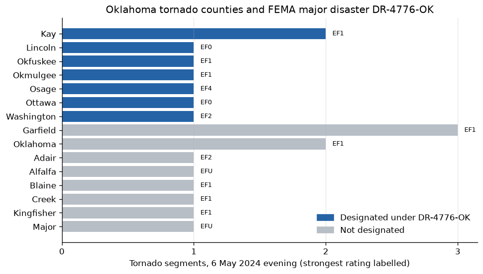
Show code
designated = sorted(joined.loc[joined["designated"], "CZ_NAME"].str.title())
not_designated = sorted(joined.loc[~joined["designated"], "CZ_NAME"].str.title())
ef4 = joined.loc[joined["strongest"] == "EF4", "CZ_NAME"].str.title().tolist()
print(
    f"{len(designated)} of {len(joined)} tornado counties were designated: {', '.join(designated)}"
)
print(f"Not designated: {', '.join(not_designated)}")
print(f"The evening's EF4 county: {', '.join(ef4)}")
7 of 15 tornado counties were designated: Kay, Lincoln, Okfuskee, Okmulgee, Osage, Ottawa, Washington
Not designated: Adair, Alfalfa, Blaine, Creek, Garfield, Kingfisher, Major, Oklahoma
The evening's EF4 county: Osage
Osage County, where the evening's one EF4 struck, is designated. Oklahoma County, where the EF1 that the severe-weather case study follows touched down, is not.
That is a statement about designation, not about damage. DR-4776 covers incidents from 25 April to 9 May, so a county can be designated for a storm on another day, and a tornado that did little harm earns no declaration. The declaration was made on 30 April, before this outbreak; the window selects by the incident period, which is why asking about 6 May finds it. Query details are in the disaster declarations guide.
Pin and cite
verify checks the cached bytes against the lockfile. FEMA revises rows as
incidents close and programs are added, and NCEI republishes the Storm Events
file under a new name when it revises a year, so a later pull can report
drift; usdata pull dataset.yaml --update <dataset> accepts the revised
bytes. Keep the manifest, lockfile, and cached bytes together; the citations
below are what a methods section needs, and usdata cite dataset.yaml prints
the same.
Show code
assert verify(manifest) == []
for citation in cite_lockfile(manifest):
    print(citation.as_text())
fema:disaster-declarations
Federal Emergency Management Agency (FEMA), OpenFEMA Dataset: Disaster Declarations Summaries - v2. Retrieved from https://www.fema.gov/api/open/v2/DisasterDeclarationsSummaries on [date, time]. This product uses the Federal Emergency Management Agency's OpenFEMA API, but is not endorsed by FEMA. The Federal Government or FEMA cannot vouch for the data or analyses derived from these data after the data have been retrieved from the Agency's website(s).
homepage: https://www.fema.gov/openfema-data-page/disaster-declarations-summaries-v2
license: US Government Work (public domain)
terms: https://www.fema.gov/about/openfema/terms-conditions
retrieved: 2026-09-24; 1 checksummed asset (10,308 bytes) pinned by usdata 0.26.0
sources: declarations
noaa:storm-events
NOAA National Centers for Environmental Information, Storm Events Database, accessed via usdata
homepage: https://www.ncei.noaa.gov/access/storm-events-database/
license: US Government Work (public domain)
terms: https://www.ncei.noaa.gov/metadata/geoportal/rest/metadata/item/gov.noaa.ncdc:C00510/html
retrieved: 2026-09-24; 1 checksummed asset (12,693,243 bytes) pinned by usdata 0.26.0
sources: reports
What was awkward
- The join silently matched only the counties whose code has three digits.
Both sources keep their county code as text, which is right, but Storm
Events writes
1and19where FEMA writes001and019. Nothing fails; small counties simply drop out of the join.str.zfill(3)fixes it, and the reader does not do it for you, because it leaves a source's values as delivered. - OpenFEMA answers a filter it cannot match with a well-formed empty result.
A full timestamp in a filter is compared against its own percent-encoded
text, so
ge '2024-05-01T00:00:00.000Z'is never true; only the filter echoed back in the response metadata, still readingT00%3A00%3A00, gives it away. The adapter sends plain dates, but a hand-written probe hits this. - Treating a missing
incidentEndDateas "still open" tripled the Oklahoma result with fire declarations from 2005 that nobody ever closed. They are excluded by default, so a disaster genuinely under way needsinclude_open: trueand brings the stale rows with it. There is no good default here, only a documented one. - The program columns arrive as
0and1, and the dates as midnight UTC timestamps in text although they are calendar dates. Neither is converted. - One evening's tornado reports cost the whole year's Storm Events file, about 13 MB compressed.